Tokyo Metro by Zuti app for iPhone and iPad
4.1 (
5851 ratings )
Travel
Navigation
Developer:
Visual IT Ltd
2.99 USD
Current version:
1.1, last update: 8 years ago
First release : 15 Sep 2010
App size: 7.97 Mb
♦ KEY FEATURES
● Designed for the first time visitor and experienced commuter.
● Simple, fast and intuitive to use.
● Full offline map and routing, works underground, no internet connection required.
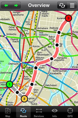
● Animates the route and allows tracking of the journey using GPS
● Instantly see the route of any transport service drawn on the map.
● Save and recall favourite and recent journeys.
● Take me home feature.
● Unique “Minute Map” feature allows quick view of all journey times from a start location.
● Services can be turned on or off, routing round problems.
● Works on iPhone or iPod and in landscape or portrait mode.
● GPS location and tracking.
● Streets, Places of interest etc built into the application.
♦ OVERVIEW
The new Tokyo Metro app makes it easy to travel in and around the city using the Toei Subway, JR East routes (within the Tokyo Suburban area), Shinkansen routes, Streetcars, some important private lines and Tokyo Cruise lines. Unlike old fashioned schematic style maps this product contains a geographically accurate central area showing major streets, parks and places of interest etc, allowing the user to easily get their bearings.
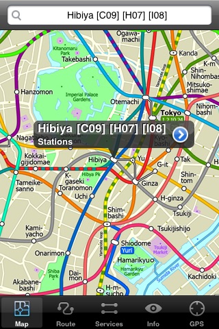
♦ MAP
The map is hand drawn by Visual IT and provides a unique geographically based view of the Tokyo Metro with many places of interest drawn directly on the background so you can easily get your bearings when traveling around the city. You can also use your inbuilt GPS to accurately locate and track yourself within the city centre and see the nearest transportation stop and distance to it. This is the only pubic transportation route planner with this ability.
Tap on the map for location information, use the inbuilt search feature or choose from a list of locations. Places of interest, museums, hotels, parks, restaurant, shops, hospitals, streets, etc, are also included. The route planner will automatically suggest the nearest station to any place of interest you select.
♦ MINUTE MAP
Another great feature is the “Minute Map” option which allows you to see the travel times from a start point to all other locations on the map. This is a unique way to view the topology of a city and gauge traveling times.
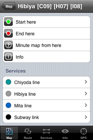
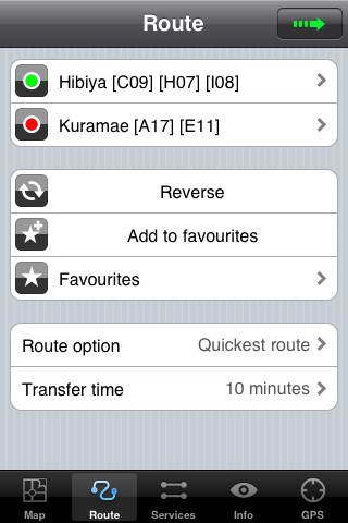
♦ ROUTING
The application does not require an internet connection and will always be available to display a clear and detailed view of the city transport systems, plus list and animate the optimum route for your journey. This product provides the fastest route calculations of any mobile routing application (virtually instantaneous) using actual published journey times with the ability to select the quickest route or the route with the least changes.
♦ MORE MAPS
This map is one in a series of Zuti worldwide city maps, if you like this product you may also enjoy some of our other offerings, please visit www.zuti.co.uk for further information.
Pros and cons of Tokyo Metro by Zuti app for iPhone and iPad
Tokyo Metro by Zuti app good for
Offline Maps work perfectly. I use this every time on my regular trips to Tokyo.
I have spent the past 10 weeks in Tokyo and I use this app almost everyday. This app has been super helpful and I recommend it to anyone that is planning to travel by train in Tokyo. I subtract 1 star because it does not know some of the quirks of the trains e.g. The Asakusa line becomes the Keikyu line at Sengakuji and it will not tell you to transfer to a local train to continue on the Asakusa, or will route you to a JR train uneccesarily if you are Shinagawa bound. There are a couple other similar quirks it doesnt know either. That said it has never gotten me lost and has simplified many many trips.
Some bad moments
Outstanding Tokyo subway app, far and away worth the price and much better than everything else available. Completely accurate, comprehensive station listing, routes accurately and clearly, and most importantly understands and includes most direct routing including footpaths between stations saving transfers. This app actually understands how Tokyo residents use their subway based on complete station and exit information. Fantastic app.
Due to the fact that there are several competing train companies in Tokyo, it is difficult to find a single map which shows both Tokyo Metro, Toei, and JR train lines. This, however, has them all. Stations are shown on a map of the city, so you can see them in relationship to each other as well as the places you want to visit. When switching between systems, knowing how to get from one close station to another (which may not actually be connected) is an excellent feature.
To major drawbacks, which cause me to give it 4 instead of 5 stars:
1) The map data dates to 2010, and thus is *slightly* out of date. For example, Musashi-Kosugi Station is now on multiple rail lines, as of March 2010. That said, I dont think that the changes are very major, but thats just my guess.
2) The maps in the stations that allow you to calculate the fare needed are only printed in Romanji (aka English script) for central Tokyo. For stations that are further out, it would be helpful if the app gave the Kanji version of the station names as well.
Everything one would expect from a Subway Map App, plus a bunch of other great features! :)
Works well to get around Tokyo. Only would add a feature for cost of tickets or cheapest route along with the two other options of quickest or fewest changes.
I downloaded several Tokyo metro apps and none match this one. This was the best app, the GPS feature gives you the nearest subway near you in Tokyo. Additionally, you can measure distances between locations on the map.
At first glance I thought the app was great until I tried to go from Roppongi to Hibashi-sinjuko. The app said stay on the Oedo line and I will get there. Wrong! You need to change trains in Tochame and for me I would have been able to see this by reading the station maps, unacceptable for a paid App to get you lost!!